
What You’ll Learn in this Post
- How lifting or evaporation and mixing produce cloud formation
- How dry air contributes to thunderstorms
- What to look for when you see clouds forming in real time
- Why adiabatic cooling by lifting contributes to cloud formation
Introduction
If you’ve been reading since the beginning of the blog, you’ve seen that cloud droplets form thanks to two ingredients: water vapor and condensation nuclei. These ingredients form cloud droplets via saturation. (If you haven’t read that post, I recommend you click the link above and read it first.) We’ve also examined the origin of rising motion that contributes to cloud formation by lifting the air, such as by surface heating, by higher terrain, by fronts, or by low-level convergence. Let’s build upon this framework by exploring why this lifting contributes to cloud formation by cooling the air.
Table of Contents
How Does Lifting Manufacture Many Cloud Droplets?
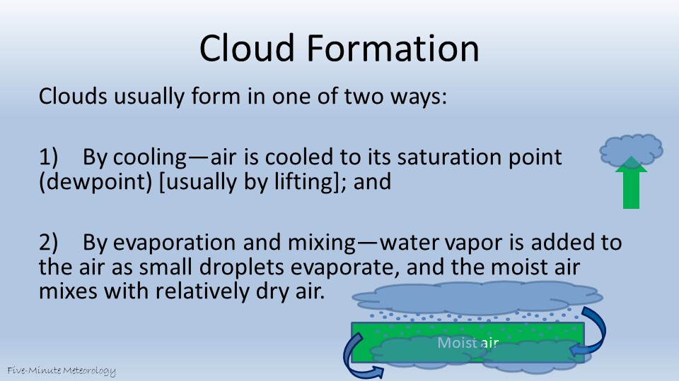
Clouds form through the rapid production of cloud droplets. The image above shows two primary ways that this rapid droplet production occurs. In the first, lifting creates rising motion. This rising motion cools the air, lowering the air temperature to saturation. Saturation creates an environment whereby rapid cloud production can occur.
Localized lifting is often created by small areas of enhanced surface heating, such as a large shopping mall parking lot. This localized lifting produces cumulus clouds. In contrast, larger-scale lifting of wide layers of moist air creates stratiform clouds. An example of the lifting of a larger layer of moist air occurs with warm fronts. We’ll explore why lifting the air causes it to cool later in this post. This cooling via lifting is critical to cloud formation.
The second cloud-producing process may be counterintuitive. You may find it surprising that mixing moist and dry air can create clouds, but we see this interaction whenever one cloud forms underneath another. The falling of liquid droplets from the upper cloud that evaporate into drier air below – such as tiny, evaporating droplets falling from a cloud into a sub-saturated layer of clear air – helps to saturate the air below with water vapor.
The key is that when those droplets evaporate in the drier air below, the water from the droplets remains in the air as water vapor. Once the air becomes saturated with water vapor, new droplets can form and a cloud can develop in the lower layer. Saturation produces condensation, and condensation produces cloud droplets.
How does dry air contribute to thunderstorm production? (Click for answer)
Dry air contributes to thunderstorm production when hydrometeors fall into a lower sub-saturated layer (the dry air) and evaporate (or sublimate if the cloud is made of ice crystals). When we explored the phase changes of water, we saw that evaporation is a cooling process. This evaporational cooling in the dry air comes in addition to evaporation’s role in moistening the air described in the paragraph above. The combined moistening and cooling of drier air by evaporation (or sublimation) promotes cloud droplet formation by bringing the air closer to saturation. With time, this can lead to cloud growth in the layer below a parent cloud.
A Video of Lifting and Cloud Formation
The video below demonstrates both how saturation contributes to cloud formation and how surface heating provides lifting. In the first few seconds of the video, as the sun is rising, clouds form over the lake as a layer of moisture blown by the wind mixes with additional moisture evaporated from the lake. After the sun rises, the surface begins to warm more rapidly over the city (and in the background) than over the lake, producing localized lifting over the city that drives cloud development there.
Why did the clouds form over the lake? (Click for answer)
Because they heard the lake was serving up some “atmospheric appetizers” – a perfect recipe for cloud formation! They couldn’t resist the tempting mix of moisture, cool air, and a touch of sunlight, creating the perfect conditions for a cloud party by the water!
Ok, the real reason that the clouds formed over the lake is that the lake is cooler, creating more stable conditions. We’ll talk for about stability in a future chapter.
In the early part of the video, the clouds grew in fits and starts, sending plumes of droplets upward which then evaporate, moistening and saturating the air in repeating cycles and mixing moist and dry air over time. Eventually, thunderstorms formed over land in the distance, while the sailboats paid them no mind on the cooler lake. By the end of the video, as surface heating subsided with the setting of the sun, the cloud cover diminished, as well.
Adiabatic Cooling and Cloud Formation
Why does cooling by lifting help to create clouds? (Click to expand)
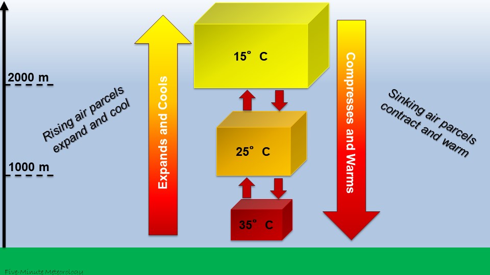
In the video above, the air is assumed to have a constant dewpoint temperature of 15°C. Play the video to see how the rising air cools to equal the dewpoint temperature. This cooling to equilibrium between the air temperature and dewpoint temperature produces saturation and creates a cloud. The cube of air that you see is referred to as an “air parcel“: a volume of air whose properties we track as it moves about the atmosphere.
The image below summarizes the behavior of rising and sinking air parcels. A rising air parcel expands to take up more space (its volume increases), becoming less dense. As the air parcel becomes less dense, the number of molecules in the air parcel hasn’t changed, but they are occupying a larger space. Therefore, there are fewer collisions between the molecules within the air parcel, producing a lower air temperature. So rising air both expands and cools.
How does air change as it sinks? (Click to expand)
The term used for this process, in which heat is not exchanged with the air parcel’s surroundings, is “adiabatic”. Rising air expands (becomes less dense) and adiabatically cools, while sinking air contracts (becomes more dense) and adiabatically warms. We’ll build upon this concept in later posts because it is fundamental to understanding many processes in the atmosphere.
The term used for the process by which air parcels expand and cool as they rise or contract and warm as they sink is called an “adiabatic” process. In an adiabatic process, heat is not exchanged with the air parcel’s surroundings. That is, ALL of the cooling or warming occurs due to the expansion or contraction of the air parcel as it rises or sinks. Rising air expands (becomes less dense) and adiabatically cools, while sinking air contracts (becomes more dense) and adiabatically warms. We’ll build upon this concept in later posts because it is fundamental to understanding many processes in the atmosphere.
Key Takeaways
- Lifting air is essential for cloud formation because it causes air to expand and cool to saturation.
- Once saturated, condensation begins, forming tiny cloud droplets. Rapid droplet production leads to cloud formation.
- Cooling or warming happens without adding or removing heat. All of this cooling or warming is due to the expansion or contraction of an air parcel. This is called an adiabatic process.
- The process depends not just on water vapor, but also on how the air moves vertically, and lifting is the mechanism that initiates rising motion.
- Surface heating, mountains, fronts, and low-level convergence are all common triggers that lift air in the real world.
Test your knowledge with the practice quiz below:
This concludes Chapter 1: Clouds and Moisture. In the next installment, we’ll summarize the posts in this chapter.

You must be logged in to post a comment.